

Luxembourg's territory

Located between Germany, Belgium and France, Luxembourg is one of the smallest countries in the world, covering a 2,586 km2 area. The country's territory is divided into two geographical regions: the Oesling up north and the Guttland in the centre and south. In the east, Luxembourg is bordered by the Moselle and Our rivers that form 135 km of natural border between the Grand Duchy and Germany. The Southern border with France is 73 km long and the Western border with Belgium 148 km.
Fact sheet of the territory
Geographical coordinates: 49° 37' of Northern latitude and 6° 08' of Eastern longitude
Area: 2,586 km2. North-South: 82 km, East-West: 57 km.
Borders: 356 km, including 148 km with Belgium, 135 km with Germany and 73 km with France.
Altitudes: maximum (Wilwerdange): 560 m; minimum (Wasserbillig): 130 m.
Main rivers: Moselle (37 km), Sûre (136 km), Alzette (67 km).
Surfaces:
Area covered by water: 0.6% of the national territory.
Farmland and forest areas: 85.2%.
Built areas: 9.7%.
Roads, railroads, etc.: 4.5%
Geographic areas
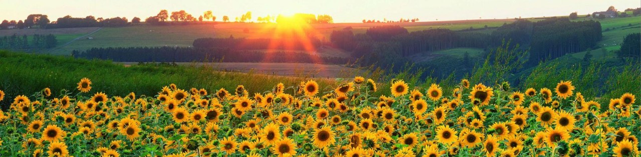
Luxembourg Ardennes
The Éislek (or Oesling), in the northern part of the country forms part of the Ardennes massif and borders the German Eifel region. It is a very green area covering 828 km2, i.e. one third of the territory. It features breathtaking landscapes where high plateaus alternate with steep slopes and wooded valleys with murmuring rivers.
In the heart of the Ardennes, the nature reserves of the Our and the Haute-Sûre, with its reservoir, which is also the largest lake in the Grand Duchy, attract nature lovers and offer many opportunities for leisure and recreation.
The highest point in the Grand Duchy (560 m) is here, in Wilwerdange. The main towns in this region are Wiltz, Clervaux and Vianden.
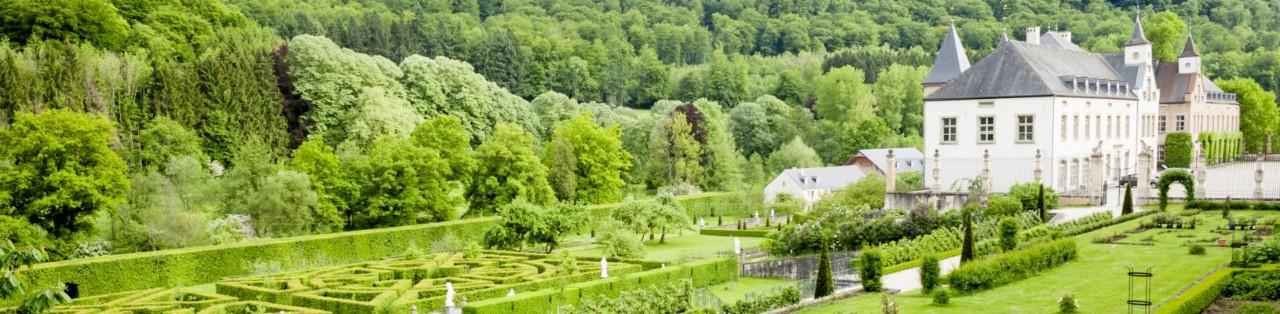
Guttland
Guttland, literally the 'good country', lies in the south and centre of the country. Together with the capital, it occupies the remainder of the country (68%, or 1,758 km2). This region is essentially made up of countryside, forests and, in the south, mining regions. Over two-thirds of this area are farmland. Several tourist regions are located in the Guttland:
The City of Luxembourg, millennial and European capital. This region and its surroundings are characterised by vast woodlands, landscaped areas, the Petrusse and Alzette valleys as well as a city harmoniously blending contemporary architecture with historical buildings and the remains of the fortress.
The Moselle valley, known as the Musel by Luxembourgish people is the Grand Duchy's most impressive valley, both in terms of size and variety of landscapes. It is one of the country's main tourist attractions, largely on account of its winemaking activities and its breathtaking sceneries.
The Mullerthal region - Luxembourg's Little Switzerland (Mëllerdall) lies in the north of the Moselle valley, bordering Germany. This region's particular appellation is owed to the many rocky hills amidst which watercourses winding their way.
The Land of the Red Rocks lies South of the country. The area has been moulded by industry where iron ore was extracted from the red earth, hence the name Minett (from 'minette', the designation for iron ore in the Lorraine) applied to this region in Lëtzebuergesch. Today, former industrial wastelands have been urbanised or converted into nature reserves.
Administrative organisation of the territory
From an administrative point of view, the territory is divided into:
- 12 cantons (Capellen, Clervaux, Diekirch, Echternach, Esch-sur-Alzette, Grevenmacher, Luxembourg, Mersch, Redange-sur-Attert, Remich, Vianden, Wiltz); the cantons do not have their own administrative structure. Instead, they serve as territorial units, on the basis of which the electoral constituencies and the administrative districts are defined.
- 100 municipalities;
- 4 electoral constituencies (south, centre, east and north);
- 2 judicial districts (Luxembourg and Diekirch) comprising 3 magistrates’ courts (Luxembourg, Esch-sur-Alzette and Diekirch).
Luxembourg City is the capital of the Grand Duchy and seat of the government.
By law, the following municipalities may actually bear the title of 'city': Diekirch, Differdange, Dudelange, Echternach, Esch-sur-Alzette, Ettelbruck, Grevenmacher, Luxembourg, Remich, Rumelange, Vianden and Wiltz.
The territory's development
Today, the Grand Duchy is one of of the smallest European states. But it was not always the case: with the acquisition of the County of Chiny in 1364, the former Duchy of Luxembourg reached its largest area in its history: 10,000 square kilometres. Over the following centuries, Luxembourg came under foreign domination and was divided three times:
- 1659 Following the Treaty of the Pyrenees, Spain gave up the southern part of the Duchy of Luxembourg, and in particular the city of Thionville, to France.
- 1815: During the Vienna congress, the Luxembourg territories of the Eifel and across the Moselle, the Sûre and the Our were allocated to Prussia.
- 1839: The London Treaty of 19 April split Luxembourg in two, its western part going to Belgium, while its eastern part continues to make up the Grand Duchy, from which Luxembourg acquired its current geographical form.
Last update